Western Rhodopes Mountains, Smolyan Province, Bulgaria
The Rhodopes Mountains are a mountain range in south east Europe. They are spread over 5689 square miles of which 4723 square miles are located in south Bulgaria and the remainder in north Greece.
The Rhodopes Mountains are about 149 miles long and about 62 to 75 miles wide with an average altitude of 2575 feet. Golyam Perelik is its highest peak at 7188 feet and is situated 12 miles to the west of Smolyan. In geomorphological terms, the Rhodopes Mountains are part of the Rilo-Rhodope massif which is the oldest landmass on the Balkan peninsula.
The Rhodopes Mountains gives its name to the terrestrial eco-region Rodope montane mixed forests that belong in the temperate broadleaf and mixed forests biome. The area is particularly notable for the largest coniferous woods in the Balkans plus its karst areas with their deep river gorges, large caves and specific sculptured forms such as the Trigrad Gorge.
The Rhodopes Mountains can be sub-divided in to 3 sections:
The Western Rhodopes are spread over 66% of the area of the Rhodopes Mountains in Bulgaria and they are higher, the most infrastructurally developed and the most visited part of the mountains. The highest and best known peaks are located in this section with more than 10 over 6562 feet high including the highest peak, Golyam Perelik (7188 feet). Some of the deepest river gorges in the Rhodopes Mountains are located in the west as well as several large lakes.
The Eastern Rhodopes are spread over a territory of about 34% of the area of the Rhodopes Mountains in Bulgaria and are much lower in height. The large artificial dams of Kardzhali and Studen Kladenets are located in this part of the mountains. Almost every species of European bird of prey nests in the Eastern Rhodopes including the rare Black Vulture and Egyptian Vulture.
The Southern Rhodopes are the part of the mountain range that is located in Greece and they are characterized by numerous peaks of relatively low altitude.
The River Buynovska is situated in the western Rhodopes Mountains and it is one of the source rivers of the River Vacha, the second largest river that has its source in the Rhodopes Mountains after the River Arda.
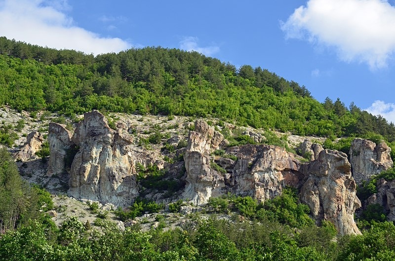
The river has formed the Buynovo Gorge, the longest gorge in Bulgaria, located between the villages of Yagodina and Teshel. Formed by erosion as the River Buynovo flows through layers of marble rock, the gorge has developed in to an impressive natural phenomenon. The cliffs on both sides of the gorge rise hundreds of feet and can be visited on foot or by car on an extremely narrow single track road which winds along the base of the cliffs with sheer drops and hairpin turns. The narrowest point of the gorge is called Vuclhi Skok (“The Wolf’s Leap”). Folklore says that during winter wolves would leap the chasm to attack the sheepfolds. While this is only a legend, it is plain to see that the gorge is so narrow at this point that the cliffs practically touch each other at height of just 10 to 13 feet above the road.
The beauty of the Buynovo Gorge can be appreciated from “a bird’s-eye view” from “The Eagle’s Eye”, a metal platform built on the precipitous cliff face of the Saint Iliya Peak at a height of 5128 feet. This provides impressive views of the entire surrounding area and, during good weather, the entire Rhodopes Mountains and even parts of north Greece are visible. Several hiking trails have been created in the area and the Buynovo Gorge was designated as a nature reserve in 1971. It is now one of Bulgaria’s top 100 tourist destinations.
The limestone sediment has been eroded throughout the entire area and in the vicinity of the village Yagodina alone there are 36 caves, the most famous of which is the Yagodina Cave itself, a multi-level complex of primarily marble. This is the 4th longest cave in Bulgaria and the longest cave in the Rhodopes Mountains at around 5 miles, of which just under 1 mile is open to tourists.
Date: 28th May 2018
Location: Teshel to Yagodina, Western Rhodopes Mountains, Smolyan Province, Bulgaria
The Rhodopes Mountains are about 149 miles long and about 62 to 75 miles wide with an average altitude of 2575 feet. Golyam Perelik is its highest peak at 7188 feet and is situated 12 miles to the west of Smolyan. In geomorphological terms, the Rhodopes Mountains are part of the Rilo-Rhodope massif which is the oldest landmass on the Balkan peninsula.
The Rhodopes Mountains gives its name to the terrestrial eco-region Rodope montane mixed forests that belong in the temperate broadleaf and mixed forests biome. The area is particularly notable for the largest coniferous woods in the Balkans plus its karst areas with their deep river gorges, large caves and specific sculptured forms such as the Trigrad Gorge.
The Rhodopes Mountains can be sub-divided in to 3 sections:
The Western Rhodopes are spread over 66% of the area of the Rhodopes Mountains in Bulgaria and they are higher, the most infrastructurally developed and the most visited part of the mountains. The highest and best known peaks are located in this section with more than 10 over 6562 feet high including the highest peak, Golyam Perelik (7188 feet). Some of the deepest river gorges in the Rhodopes Mountains are located in the west as well as several large lakes.
The Eastern Rhodopes are spread over a territory of about 34% of the area of the Rhodopes Mountains in Bulgaria and are much lower in height. The large artificial dams of Kardzhali and Studen Kladenets are located in this part of the mountains. Almost every species of European bird of prey nests in the Eastern Rhodopes including the rare Black Vulture and Egyptian Vulture.
The Southern Rhodopes are the part of the mountain range that is located in Greece and they are characterized by numerous peaks of relatively low altitude.
The River Buynovska is situated in the western Rhodopes Mountains and it is one of the source rivers of the River Vacha, the second largest river that has its source in the Rhodopes Mountains after the River Arda.
The river has formed the Buynovo Gorge, the longest gorge in Bulgaria, located between the villages of Yagodina and Teshel. Formed by erosion as the River Buynovo flows through layers of marble rock, the gorge has developed in to an impressive natural phenomenon. The cliffs on both sides of the gorge rise hundreds of feet and can be visited on foot or by car on an extremely narrow single track road which winds along the base of the cliffs with sheer drops and hairpin turns. The narrowest point of the gorge is called Vuclhi Skok (“The Wolf’s Leap”). Folklore says that during winter wolves would leap the chasm to attack the sheepfolds. While this is only a legend, it is plain to see that the gorge is so narrow at this point that the cliffs practically touch each other at height of just 10 to 13 feet above the road.
The beauty of the Buynovo Gorge can be appreciated from “a bird’s-eye view” from “The Eagle’s Eye”, a metal platform built on the precipitous cliff face of the Saint Iliya Peak at a height of 5128 feet. This provides impressive views of the entire surrounding area and, during good weather, the entire Rhodopes Mountains and even parts of north Greece are visible. Several hiking trails have been created in the area and the Buynovo Gorge was designated as a nature reserve in 1971. It is now one of Bulgaria’s top 100 tourist destinations.
The limestone sediment has been eroded throughout the entire area and in the vicinity of the village Yagodina alone there are 36 caves, the most famous of which is the Yagodina Cave itself, a multi-level complex of primarily marble. This is the 4th longest cave in Bulgaria and the longest cave in the Rhodopes Mountains at around 5 miles, of which just under 1 mile is open to tourists.
Date: 28th May 2018
Location: Teshel to Yagodina, Western Rhodopes Mountains, Smolyan Province, Bulgaria
|

Also in: Bulgaria
 |  |  |  |  |
 |  |  |  |  |
 |  |  |  |  |