Făgăraș Mountains, Sibiu County, Romania
The Făgăraș Mountains, commonly known as the “Transylvanian Alps”, are a mountain range in the Southern Carpathians in central Romania. Spread over 43.5 miles from east to west and 28 miles from north to south, the range resembles an immense spine with steep peaks facing north and more gentle ones to the south.
The steep north face of the Făgăraș Mountains rises above 8,000 feet and overlooks the Făgăraş Depression or Făgăraş Hollow through which flows the River Olt. The range is bordered to the east by the Piatra Craiului Mountains and by the Oltului Gorge to the west.
The mountains are heavily glaciated with lakes, fretted peaks and morainic deposits. The highest peaks, which are also the highest mountains in Romania, are Moldoveanu (8346 feet), Negoiu (8317 feet) and Viștea Mare (8291 feet) and they are covered by snow for 8 to 9 months of the year. There are several other peaks over 8000 feet. Bâlea is the largest lake, Podragu is the deepest lake and the highest lake is in the Hărtopul Leaotei glacial valley. Other lakes include Urlea and Capra.
A road known as the Transfăgărășan (road DN7C) runs across the Făgăraș Mountains. It has been described as the "Road to the Sky", the "Road to the Clouds" and the "Best Driving Road in the World" and it is a stunning scenic drive. The road climbs to a height of 6699 feet at Pasul Bâlea, making it the second highest mountain pass in Romania after the Transalpina. It starts at Bascov near Pitești and follows the valley of the River Argea. After mounting the highest point, between the high peaks of Moldoveanu and Negoiu, it descends to Cârțișoara in the valley of the River Olt. It is a winding road and is dotted with steep hairpin turns, long S-curves and sharp descents and it is usually closed from late October until late June because of snow. Depending on the weather, it may remain open until as late as November or it may close even in the summer. The Transfăgărășan has more tunnels (5) and viaducts (27) than any other road in Romania. Near the highest point, at Bâlea Lake, the road passes through Bâlea Tunnel, the longest road tunnel in Romania at 2900 feet.
The Transfăgărășan was constructed between 1970 and 1974 during the rule of Nicolae Ceaușescu as a response to the 1968 invasion of Czechoslovakia by the Soviet Union. Ceaușescu wanted to ensure quick military access across the mountains in case of a Soviet Union invasion. At the time, Romania already had several strategic mountain passes through the Southern Carpathians, whether inherited from the pre-Communist era (road DN1 and road DN67C) or built during the initial years of the Communist regime (road DN66). These passes, however, were mainly through river valleys and they would have been easy for the Soviet Union to block and attack. Ceauşescu therefore ordered the construction of a road across the Făgăraş Mountains. Built mainly by junior military forces, the road had a high financial and human cost since work was carried out in an alpine climate at an elevation of 6600 feet. The road was officially opened on 20th September 1974 although work continued until 1980.
Date: 7th June 2018
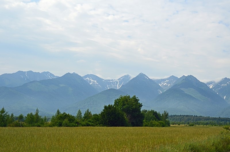
Location: Făgăraș Mountains from near Cârțișoara, Sibiu County, Romania
The steep north face of the Făgăraș Mountains rises above 8,000 feet and overlooks the Făgăraş Depression or Făgăraş Hollow through which flows the River Olt. The range is bordered to the east by the Piatra Craiului Mountains and by the Oltului Gorge to the west.
The mountains are heavily glaciated with lakes, fretted peaks and morainic deposits. The highest peaks, which are also the highest mountains in Romania, are Moldoveanu (8346 feet), Negoiu (8317 feet) and Viștea Mare (8291 feet) and they are covered by snow for 8 to 9 months of the year. There are several other peaks over 8000 feet. Bâlea is the largest lake, Podragu is the deepest lake and the highest lake is in the Hărtopul Leaotei glacial valley. Other lakes include Urlea and Capra.
A road known as the Transfăgărășan (road DN7C) runs across the Făgăraș Mountains. It has been described as the "Road to the Sky", the "Road to the Clouds" and the "Best Driving Road in the World" and it is a stunning scenic drive. The road climbs to a height of 6699 feet at Pasul Bâlea, making it the second highest mountain pass in Romania after the Transalpina. It starts at Bascov near Pitești and follows the valley of the River Argea. After mounting the highest point, between the high peaks of Moldoveanu and Negoiu, it descends to Cârțișoara in the valley of the River Olt. It is a winding road and is dotted with steep hairpin turns, long S-curves and sharp descents and it is usually closed from late October until late June because of snow. Depending on the weather, it may remain open until as late as November or it may close even in the summer. The Transfăgărășan has more tunnels (5) and viaducts (27) than any other road in Romania. Near the highest point, at Bâlea Lake, the road passes through Bâlea Tunnel, the longest road tunnel in Romania at 2900 feet.
The Transfăgărășan was constructed between 1970 and 1974 during the rule of Nicolae Ceaușescu as a response to the 1968 invasion of Czechoslovakia by the Soviet Union. Ceaușescu wanted to ensure quick military access across the mountains in case of a Soviet Union invasion. At the time, Romania already had several strategic mountain passes through the Southern Carpathians, whether inherited from the pre-Communist era (road DN1 and road DN67C) or built during the initial years of the Communist regime (road DN66). These passes, however, were mainly through river valleys and they would have been easy for the Soviet Union to block and attack. Ceauşescu therefore ordered the construction of a road across the Făgăraş Mountains. Built mainly by junior military forces, the road had a high financial and human cost since work was carried out in an alpine climate at an elevation of 6600 feet. The road was officially opened on 20th September 1974 although work continued until 1980.
Date: 7th June 2018
Location: Făgăraș Mountains from near Cârțișoara, Sibiu County, Romania
|
Next (1 of 100)
|
Also in: Romania
 |  |  |  |  |
 |  |  |  |  |
 |  |  |  |  |