Vardø, Varanger peninsula, Troms og Finnmark, Norway
Vardø is a town and municipality in Troms og Finnmark in the extreme north east of Norway. It is the eastern most town in Vardø is a town and municipality in Troms og Finnmark in the extreme north east of Norway. It is the eastern most town in Norway and the Nordic countries, located at 31°E, which is east of Saint Petersburg, Kiev and Istanbul.
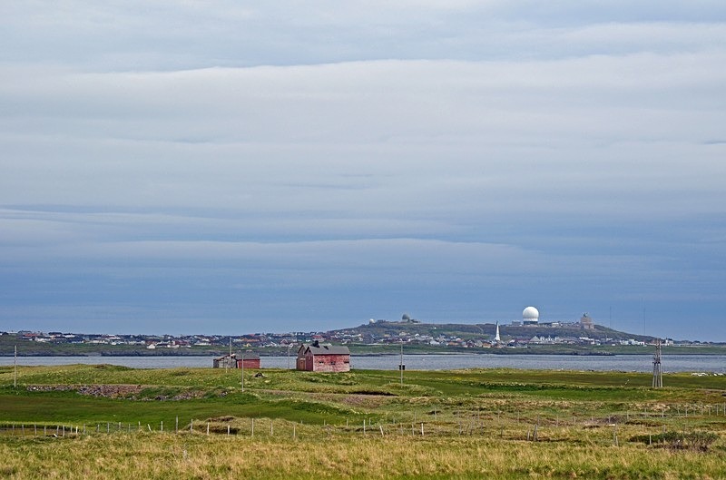
The town of Vardø is located on the island of Vardøya at the mouth of the Varangerfjord but the municipality includes significant area on the mainland of the Varanger peninsula including part of the Varangerhalvøya National Park in the south west. The mountain Domen lies overlooks Vardøya and Vardø. The island of Vardøya is surrounded by a few smaller islands including the bird reserve of Hornøya.
The island of Vardøya is connected to the mainland via the undersea Vardø Tunnel (Norway's first such structure). Vardø Airport and the village and port of Svartnes are on the mainland opposite the tunnel entrance.
Vardø is a port of call on Norway's Hurtigruten ferry service and it is the northern termination of European route E75 which starts in Sitia in Crete.
Vardø has a long settlement history before it was granted status as a town in 1789. Several stone-age sites as well as sites dating from the Sami Iron Age are known on the island. In the Medieval period, Vardø's importance grew as a result of it being the easternmost stronghold of the then-expanding Norwegian royal power. A church was built in Vardø in 1307 and the first fortress was established at about the same time.
Even if the presence of the fortress and King's bailiff gave Vardø a certain degree of permanence and stability not experienced by other fishing communities in Finnmark, the town's size and importance waxed and waned with the changing fortunes of the fisheries.
After 1850, the town saw a marked expansion. The fisheries grew in importance as did trade with Russia's White Sea region. However, during World War 2, with Norway occupied by the Germans, Vardø was heavily bombed by Allied forces, principally Russian, and most of the town centre was destroyed and the population was evacuated. After the war, the town was completely reconstructed but older, traditional houses survived in the periphery.
From 1995 to 2017, the population of Vardø shrank by 50 percent to just over 2000 people, primarily as a result of the collapse of the fisheries.
Since 1998, Vardø has housed a radar installation called Globus II. Its official purpose is the tracking of space junk but, due to the site's proximity to Russia and an alleged connection between the Globus II system and US anti-missile systems, the site has been the basis for heated controversy in diplomatic and intelligence circles.
In May 2017, work to lay a new electric cable from the Norwegian mainland to the island began. The additional electricity is needed to power an American-funded radar system about 40 miles from Russia's Kola Peninsula, a territory studded with high-security naval bases and restricted military zones. The secrecy surrounding the radar systems has spawned fears that officials are covering up health hazards and other possible dangers. The electromagnetic pulses the current radar system emits interfere with television and radio reception and some residents have blamed them for a rash of miscarriages and cancer cases in a civilian district next to the fenced-in security zone.
Date: 2nd July 2019
Location: view from near Svartnes, Varanger peninsula, Troms og Finnmark, Norway
|
Also in: North Norway
 |  |  |  |  |
 |  |  |  |  |
 |  |  |  |  |