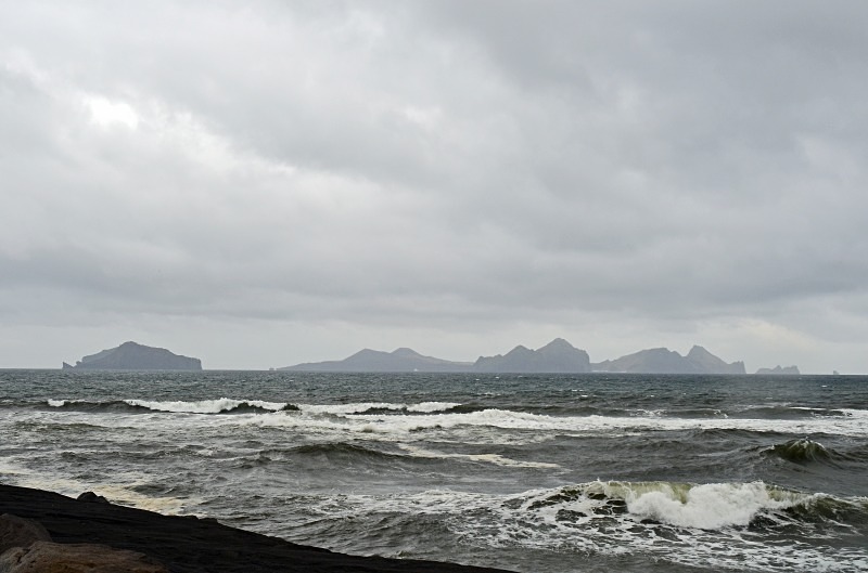
Vestmannaeyjar archipelago, south Iceland
Vestmannaeyjar, anglicized as Westman Islands, is a town and archipelago off the south coast of Iceland.
The Vestmannaeyjar archipelago is about 24 miles long and 18 miles broad with the closest point lying about 5 miles from the mainland. The largest island is Heimaey with a population of around 4000 but the other islands are uninhabited.
The archipelago is young in geological terms. The islands lie in the Southern Icelandic Volcanic Zone and have been formed by eruptions over the past 10000 to 12000 years. The volcanic system consists of 70 to 80 volcanoes both above and below the sea. There are 15 islands and about 30 rock stacks and skerries. All the islands have been built up in submarine eruptions and consist of alternating layers of tuff and lava. The oldest geological formations are in the northern part of Heimaey, the largest island and the only inhabited one. Basalt columns can be seen in many places and the sea has eroded the soft rock of the shoreline and scooped out many picturesque coves and grottos which are among the special features of the islands.
There was a submarine eruption south east of Hellisey in 1896. The next eruption began on 14th November 1963. It lasted about 4 years, one of the longest in Icelandic history, and gave birth to Surtsey which became the 15th island in the Vestmannaeyjar archipelago. The Vestmannaeyjar archipelago came to further international attention in 1973 with the eruption of the Eldfell volcano which destroyed many buildings in Heimay and forced a month long evacuation of the entire population to mainland Iceland. Approximately one fifth of the town was destroyed before the lava flow was halted by application of 6.8 billion litres of cold sea water. The eruption of 1973 lasted for 155 days and Heimaey grew in size by about 0.81 square miles.
Date: 8th June 2015
Location: view from the Landeyjahöfn ferry terminal looking south towards the Vestmannaeyjar archipelago
|
Next (1 of 47)
|
Also in: South Iceland
 |  |  |  |  |
 |  |  |  |  |
 |  |  |  |  |