Loch Indaal, Islay, Argyll

Loch Indaal is a large sea loch on the island of Islay in Argyll. It extends northwards from the Mull of Oa and Laggan Bay in the east and the Rhinns of Islay in the west. Almost splitting the island in half, it is only separated from the southern end of Loch Gruinart by a 2 mile stretch of land.
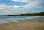
The shores of Loch Indaal are approximately 35 miles long and show a variety of landscapes, such as the high cliffs at Lower Killeyan, the 7 miles of sandy beach at Laggan Bay, the beaches at the head of the loch near Black Rock, the mudflats and salt marshes at the head of the loch near Bridgend and the rocky beaches from Bruichladdich to Rinns Point.
The whole coastline of Loch Indaal is interesting for its rich wildlife and birds can be seen from almost any location. During late autumn and winter, the mudflats and salt marshes near Bridgend hold a very large roost of Barnacle Geese.
The main settlements along the loch are Bridgend and Bowmore along the eastern shore and Bruichladdich and Port Charlotte along the western shore. The A846 from Bowmore to Bridgend and the A847 from Bridgend to Portnahaven are the roads leading around the loch.
Date: 4th November 2017
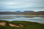
Location: view from the A846 near Bridgend
The shores of Loch Indaal are approximately 35 miles long and show a variety of landscapes, such as the high cliffs at Lower Killeyan, the 7 miles of sandy beach at Laggan Bay, the beaches at the head of the loch near Black Rock, the mudflats and salt marshes at the head of the loch near Bridgend and the rocky beaches from Bruichladdich to Rinns Point.
The whole coastline of Loch Indaal is interesting for its rich wildlife and birds can be seen from almost any location. During late autumn and winter, the mudflats and salt marshes near Bridgend hold a very large roost of Barnacle Geese.
The main settlements along the loch are Bridgend and Bowmore along the eastern shore and Bruichladdich and Port Charlotte along the western shore. The A846 from Bowmore to Bridgend and the A847 from Bridgend to Portnahaven are the roads leading around the loch.
Date: 4th November 2017
Location: view from the A846 near Bridgend
|
Also in: Sea and sand
 |  |  |  |  |
 |  |  |  |  |
 |  |  |  |  |